

 Purpose
The Comprehensive Plan Map Clarification Project will create a property-specific Comprehensive Plan Map for Springfield. This map will add greater certainty to Springfield’s plan designations.
Currently, the Metro Plan and its Diagram, i.e., map, serve as a combined Eugene-Springfield comprehensive plan to guide decisions about how to use land within the region. The Metro Plan Diagram does not meet today’s needs for showing which plan designations, general land use types, apply to each property within the region. The Metro Plan Diagram is a “broad brush,” graphic depiction of projected land uses and major transportation corridors.
Clarifying the location of the plan designations by interpreting the Metro Plan Diagram for each property within Springfield’s urban growth boundary will provide a solid understanding of existing policies and plan documents in a visual way and will streamline the land use research process with better property lookup tools.
Recursos en español:
Si tiene preguntas o desea solicitar información sobre este proyecto en español, comuníquese con Molly Markarian, Planificadora Urbana, al mmarkarian@springfield-or.gov o al 541-726-4611
Preguntas Frecuentes – Preguntas frecuentes con respuestas sobre el proyecto de clarificación del mapa del plan integral.

 Project Updates
January 17, 2024: Adoption of Springfield Comprehensive Plan Map and Land Use Element
On January 9, 2024, the Lane County Board of Commissioners adopted Ordinance 23-07 and Ordinance PA 1390. These County Ordinances relate to Springfield’s Ordinance 6463 (adopted November 20, 2023) to adopt the Springfield Comprehensive Plan Map and Land Use Element along with accompanying amendments to the Eugene-Springfield Metropolitan Area General Plan (Metro Plan), Springfield’s neighborhood refinement plans, and the Springfield Development Code.
These amendments will be in effect as of March 1, 2024.
December 5, 2023: City Council Adoption and Upcoming Lane County Board Meeting
On November 20, 2023, Springfield City Council conducted the second reading and adopted Ordinance 6463 to adopt the Springfield Comprehensive Plan Map and Land Use Element along with accompanying amendments to the Eugene-Springfield Metropolitan Area General Plan (Metro Plan), Springfield’s neighborhood refinement plans, and the Springfield Development Code.
The Lane County Board of Commissioners is scheduled for the third reading and adoption of the related Lane County Ordinances on January 9, 2024. The Board’s meeting packet will be available on the Lane County Board of Commissioners webpage prior to the meeting.
Once adopted by the City and County, the amendments will be in effect as of March 1, 2024.
November 13, 2023: Final Steps in the Adoption Process
On November 20, 2023, Council is scheduled for the second reading of an Ordinance to adopt the Springfield Comprehensive Plan Map and Land Use Element along with accompanying amendments to the Eugene-Springfield Metropolitan Area General Plan (Metro Plan), Springfield’s neighborhood refinement plans, and the Springfield Development Code. The Council will meet in-person at Springfield City Hall and also use virtual meeting technology. Meeting information and materials will be available on the Springfield City Council webpage prior to the meeting.
Following Council adoption, the Lane County Board of Commissioners is scheduled for the third reading and adoption of the related Lane County Ordinances on January 9, 2024. The Board’s meeting packet will be available on the Lane County Board of Commissioners webpage prior to the meeting.
Once adopted by the City and County, the amendments will be in effect as of March 1, 2024.
September 15, 2023: Upcoming Joint Elected Officials Public Hearing
The Springfield City Council and Lane County Board of Commissioners will hold a joint work session and public hearing on October 16, 2023 to consider adoption of a property-specific Springfield Comprehensive Plan Map and related text amendments. The Council and Board will meet in-person at Springfield City Hall and also use virtual meeting technology.
To attend the work session, participate in the public hearing, or submit testimony:
Written testimony can be submitted via email to chartman@springfield-or.gov or dropped off or mailed to: Development & Public Works Department, City of Springfield, Attn: Chelsea Hartman, 225 Fifth Street, Springfield, Oregon 97477. All written comments will be provided to the Council and Board. Oral testimony must be provided at the public hearing:
- Join virtually from a computer, tablet, or smart phone or dial in by phone. Registration required – Visit https://springfield-or.gov/city/city-council-meetings/
- In Person: Council Chambers, Springfield City Hall, 225 5th Street. No RSVP required.
The draft Ordinance and proposed amendments are shown in the following documents:
- Draft Springfield City Council Ordinance and Draft Lane County Board of Commissioners Ordinance
- Exhibit A – Draft Springfield Comprehensive Plan Amendments
- Exhibit B – Revised* Draft Metro Plan Amendments
- Exhibit C – Revised Draft Neighborhood Refinement Plan Amendments for Co-adoption
- Exhibit D – Revised Draft Neighborhood Refinement Plan Amendments (Springfield-only adoption)
- Exhibit E – Revised Draft Downtown Refinement Plan Amendments (Springfield-only adoption)
- Exhibit F – Revised Draft Springfield Development Code Amendments
- Exhibit G – Draft Staff Report and Findings
*Note: Documents noted as “Revised” include changes made since the Planning Commission Order and Recommendation.
The meeting packet for the October 16 joint work session and public hearing will be available on the Springfield City Council webpage prior to the meeting. Council is scheduled to hold a second reading of the Ordinance on November 20, 2023. After the Council adopts the Ordinance, the Board will hold its third reading of the Ordinance in early 2024.
July 31, 2023: Planning Commissions Recommendation & Next Steps
The Springfield and Lane County Planning Commissions held a joint work session and public hearing on July 18, 2023 and unanimously recommended approval of the proposed Comprehensive Plan Map and supporting text amendments. The related materials are shown in the following documents:
- Exhibit A – Draft Springfield Comprehensive Plan Amendments (maps)
- Exhibit A – Draft Springfield Comprehensive Plan Amendments (text)
- Exhibit B – Draft Metro Plan Amendments
- Exhibit C – Draft Neighborhood Refinement Plan Amendments for Co-adoption
- Exhibit D – Draft Neighborhood Refinement Plan Amendments for Springfield-only adoption
- Exhibit E – Draft Downtown Refinement Plan Amendments (Springfield adoption)
- Exhibit F – Draft Springfield Development Code Amendments
- Exhibit G – Staff Report and Findings
Next steps in the adoption process are a joint work session and public hearing with the Springfield City Council and Lane County Board of Commissioners, which is scheduled for October 16, 2023. More meeting details about how to participate or provide public comment will be provided closer to the meeting date.
June 22, 2023: Adoption Process to Begin in July
The Springfield and Lane County Planning Commissions will hold a joint work session and public hearing on July 18, 2023 to consider a recommendation to adopt the proposed Comprehensive Plan Map along with text needed to support the Map. Scroll to the Meetings, Events, and Timeline section for details on how to join the meeting and for access to the packet of materials proposed for adoption. The next steps in the adoption process are a work session and public hearing with the Springfield City Council and Lane County Board of Commissioners (dates TBD).
April 17, 2023 : Draft 1 of Springfield’s Comprehensive Plan Map is Ready!
Over the second half of 2022, Springfield’s Comprehensive Plan Map Clarification project team performed detailed property research and met numerous times with the project’s advisory groups, the Project Advisory Committee (PAC) and Technical Resource Group (TRG), refining and revising efforts in the process. A summary of those discussions can be found on this page under Project Documents & Resources. In Spring 2023, the project team completed a first draft of Springfield’s Comprehensive Plan Map and shared the draft for community review and sought feedback through an online comment form and in-person open house that was held on May 4.
The map is available as both a PDF map as well as a web-based, interactive map (also linked below). These two map options are similar, but they present information slightly differently with the PDF being a more simplified, illustrative map while the web map shows more detail. Our goal is to make both available to use and easy to access online and at City Hall once the final versions are complete later this year. Finally, the team has prepared an interactive and engaging project storyboard for community members and anyone interested in the project to gain a quick understanding for the need, process, and benefits of this project.
Updated Comprehensive Plan Map: PDF version (static) or Interactive version
June 7, 2022: Springfield Committee for Citizen Involvement (CCI) appoints members of Project Advisory Committee:
The Springfield Planning Commission, in its role as the Springfield CCI, reviewed and appointed all eight applicants for the Project Advisory Committee at its June 7, 2022 meeting. Meeting materials, including applicant information and a summary of recruitment, are available at: https://springfieldoregonspeaks.org/items/273
March 1, 2022: Springfield Committee for Citizen Involvement (CCI) Approves Community Engagement Plan and draft Project Advisory Committee (PAC) Bylaws
The Springfield Planning Commission, in its role as the Springfield CCI, reviewed and provided direction on a draft of the Community Engagement Plan during its March 1, 2022 meeting. A presentation accompanied this meeting. Staff modified the Community Engagement Plan based on the CCI’s input. The Project Advisory Committee (PAC) will discuss the draft bylaws at its first meeting and will have the opportunity to propose adjustments to the bylaws in order to tailor them to fit the purpose and needs of the PAC.
 Why this Work Matters
Local Ownership & Decision-Making: Springfield will have its own, adopted Comprehensive Plan Map that shows plan designations within Springfield’s urban growth boundary. This map will become one part of the Land Use Element, a chapter of the Springfield Comprehensive Plan.
Better Customer Service: The property-specific Comprehensive Plan Map will allow for timely, accurate answers. It will provide the public with property research tools that are convenient, quick to access, and easy to use—ultimately providing confidence in decisions about property. In addition to a PDF map, it will become part of Springfield’s existing property research tool, MapSpring, a web-based interactive map that is free to access from anywhere through the internet. Community members will be able to identify a plan designation for specific properties throughout Springfield by using this tool without immediate reliance on staff for basic answers.
Large Projects on the Horizon & Requirements: Cities in Oregon are required to plan for future housing needs and determine whether there is enough buildable land to meet needs for projected long-term growth. To do this, Cities must complete a Buildable Lands Inventory, which establishes supply of land available for development, and a Housing Needs Analysis (Housing Capacity Analysis), which establishes housing supply and mix needed to meet current and future demand. House Bill 2003, passed in 2019, requires cities outside the Portland Metro area with a population of greater than 20,000 to update their Housing Needs Analysis (Housing Capacity Analysis) at least every eight years. Springfield’s required adoption date is 2025. Having an accurate Comprehensive Plan Map on which to base the inventory of residential lands to inform the Housing Needs Analysis (Housing Capacity Analysis) is a desirable first step that this project will address.
Identified Barriers: Research during this project will identify conflicts between a property’s zoning and its Comprehensive Plan designation. Resolving these discrepancies can improve the pace at which housing plans and permits can be approved, thereby increasing housing availability, accessibility, and affordability. Knowing how many properties have plan-zone conflicts will allow staff to understand the magnitude of this barrier to development.
 Key Project Outcomes
The project will:
- Interpret the generalized locations of currently adopted plan designations on the Metro Plan Diagram to provide specificity by showing how those designations apply to each property in Springfield. This project is not a visioning project that explores what “will be.” It will not change already-adopted plan designations.
- Create useful information, get the facts right and clarify “what is” to provide Springfield its own, adopted Comprehensive Plan Map that shows plan designations within City’s urban growth boundary.
- Establish an accurate foundation to enable decisions about property that are sound and are based on quality research.
- Clarify what steps the City needs to take to eliminate barriers to development for properties where such barriers are caused by conflicts between how a property is zoned and how it is designated by the Comprehensive Plan.
- Provide a property-specific Comprehensive Plan Map to serve as the basis for a future buildable lands inventory project.
- Position the City to adopt a Housing Needs Analysis (Housing Capacity Analysis) and take measures to improve the accessibility and affordability of housing to meet the community’s needs in compliance with Oregon Statewide Planning Goal 10, Housing.
- Deliver and maintain better and more accessible tools for the public to make property research easier.
- Maintain a “no surprises” approach to confirming plan designations by seeking the knowledge of property owners in the research and interpretation process.
- Ensure that, before finalizing the Comprehensive Plan Map, community members will be able to identify the plan designation for every individual property on the draft map.
- Provide multiple opportunities for Springfield community members and project partners to review draft materials, ask questions, and provide input on the project.
 Meetings, Events & Timeline
This project scope and schedule provide several opportunities for engagement in a variety of formats. Opportunities range from one-on-one communications with project staff, to virtual events, to formal hearings.
Scheduled Meetings:
- None
- January 9, 2024: The Lane County Board of Commissioners held its third reading and adopted Ordinance 23-07 and Ordinance PA 1390 for the Springfield Comprehensive Plan Map and Land Use Element and the related amendments. The meeting recording is available here.
- November 20, 2023: The Springfield City Council conducted the second reading and adopted the Ordinance 6463 for the Springfield Comprehensive Plan Map and Land Use Element and the related amendments. View the meeting materials and recording.
- October 16, 2023: The Springfield City Council and Lane County Board of Commissioners conducted a joint work session and public hearing to adopt the Springfield Comprehensive Plan Map and Land Use Element along with consideration of accompanying amendments to the Eugene-Springfield Metropolitan Area General Plan, Springfield’s refinement plans, and the Springfield Development Code. View the meeting materials and recording.
- July 18, 2023:
- The Springfield and Lane County Planning Commissions held a joint work session and public hearing and unanimously recommended approval of the Springfield Comprehensive Plan Map and Land Use Element along with accompanying amendments to the Eugene-Springfield Metropolitan Area General Plan, Springfield’s refinement plans, and the Springfield Development Code. Materials and a recording of the discussion can be found here.
- May 23, 2023: (1-2:30 PM)
- The Project Advisory Committee held its fifth meeting to discuss the draft Comprehensive Plan Map.
- Meeting Materials:
Agenda
Meeting Memo
Updated Comprehensive Plan Map (PDF)
Meeting Notes
- May 4, 2023:
- Project open house: We invite you to drop by to view the draft map, ask questions, and give feedback on the draft map.
5:30 to 7:30 p.m. on Thursday, May 4 at Thurston High School’s Library, 333 58th Street in Springfield
Drop in at your convenience; no RSVP needed. Light refreshments & kid-focused activities too!
- Project open house: We invite you to drop by to view the draft map, ask questions, and give feedback on the draft map.
- March 1, 2023:
- The Technical Resource Group met to discuss the draft Comprehensive Plan Map.
- Meeting Materials:
Agenda
Meeting Memo
Comprehensive Plan Map Draft PDF (2-22-23)
PAC and TRG Combined Discussion Summary
- February 28, 2023:
- The Project Advisory Committee held its fourth meeting to discuss the draft Comprehensive Plan Map.
- Meeting Materials:
Agenda
Meeting Memo
Comprehensive Plan Map Draft PDF (2-22-23)
PAC and TRG Combined Discussion Summary
Meeting Notes
- November 28, 2022, 5:30pm:
- The Springfield City Council provided guidance on key policy questions to inform the draft map at a work session. View the recording or meeting materials.
- November 1, 2022, 6pm:
- The Springfield Planning Commission provided feedback on key policy questions to inform the draft map at a work session. Materials and a recording of the discussion can be found here.
- October 3, 2022:
- The Technical Resource Group met to discuss key questions about the upcoming Comprehensive Plan Map draft.
- Meeting Materials:
Questions for Discussion
- September 29, 2022, 4-6pm:
- The Project Advisory Committee held its third meeting to discuss and provide insights on key Comprehensive Plan Map Clarification questions.
- Meeting Materials:
Agenda
Questions for Discussion
Meeting Notes
- September 15, 2022:
- The Technical Resource Group met to discuss key questions about the upcoming Comprehensive Plan Map draft.
- Meeting Materials:
Questions for Discussion
- September 14, 2022, 4-6pm:
- The Project Advisory Committee held its second meeting to discuss and provide insights on key Comprehensive Plan Map Clarification questions.
- Meeting Materials:
Agenda
Questions for Discussion
Memo from City Attorney’s Office
Oregon Cities Interview Findings
Meeting Notes
- August 22, 2022:
- The Technical Resource Group met to discuss key questions about the upcoming Comprehensive Plan Map draft.
- July 26, 2022:
- The Project Advisory Committee held its first meeting to kick off its effort to guide the project team on work products.
- Meeting Materials:
Agenda
Draft Bylaws
Meeting Notes
- March 1, 2022:
- The Springfield Committee for Citizen Involvement approved the Community Engagement Plan for the project. Learn more about this meeting at Springfield Oregon Speaks, and see the current Community Engagement Plan under Project Documents & Resources below.
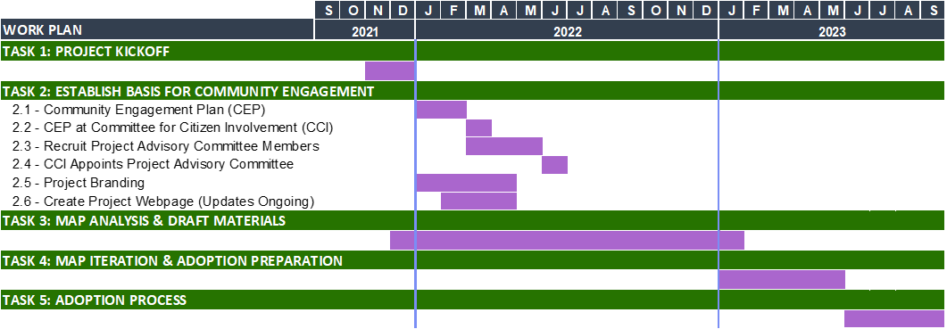
Below is a high-level timeline that shows the project’s intended phasing from November 2021 through 2023. It represents the process and estimated timeline for review, feedback, and ultimate adoption of a property-specific Comprehensive Plan Map.
Estimated Project Timeline
 Frequently Asked Questions
Click on the + icon to open or close the answer to a question.
Comprehensive Plan Maps establish “plan designations” for the use of lands in a city or county. When it comes to land use requirements, most people are more familiar with the concept of “zoning.” Zoning and plan designations are closely related, but they are separate tools. Plan designations on a Comprehensive Plan Map are used as a policy and planning tool and tend to be more high-level. They reflect the community’s vision and generally identify the type, location, and intensity of future development.
Zoning, in contrast, is used as an “implementation” tool for realizing the overall vision in the Comprehensive Plan Map. Zoning is typically more detailed. For example, it identifies allowable uses within a specific zone and can specify standards for design and development of properties and buildings. It is subservient to, and should be consistent with, the Comprehensive Plan Map which takes legal precedence for land use decisions and is the visual component of the guiding land use document for each local jurisdiction.
|
Plan Designation |
Zoning District |
|
|
This project will clarify the boundaries of plan designations depicted on the original Metro Plan Diagram, which was adopted in 2004 as an 11” x 17” paper map. The Diagram is a high-level map that conceptually shows general land uses in an area at a metropolitan scale but is generally not property specific. For example, the scale of the adopted Metro Plan Diagram translates to a line that’s approximately 150 feet wide. The City will need to research which designation, or map color, should show up on the map for the properties that fall within this distance. Research tools will include the City’s permit database, previous land use decisions, and more.
Increasing the understanding of what the Springfield community wants more of and where, such as housing, industry, and open-space, and making a plan for how land use can help accomplish those goals is an important part of our work, but it is outside the scope of this project.
This project will clarify the location of plan designations for properties within Springfield city limits. It will also clarify or verify plan designations between city limits and Springfield’s urban growth boundary (UGB), which designates where Springfield expects to grow over the next 20 years. In some areas, the UGB has recently been expanded (see Ordinance 6361); the properties in this area already have property-specific plan designations, and staff will review the map to make sure they are accurately shown.
The property-specific Comprehensive Plan Map will allow for timely, accurate answers. It will provide the public property research tools that are convenient, quick to access, and easy to use—ultimately providing confidence in decisions about property. In addition to a PDF map, the property-specific map will become part of Springfield’s existing property research tool, MapSpring, which is a web-based interactive map that is free to access from anywhere through the internet. Any future shifts from MapSpring to a similar tool will look similar and will also be free to access. Users will be able to identify a plan designation for specific properties throughout Springfield with this tool without immediate reliance on staff for basic answers.
This project will not change already-adopted plan designations. It is about interpreting the generalized locations of currently adopted plan designations on the Metro Plan Diagram to provide specificity by showing how those designations apply to each property in Springfield.
Before finalizing the Comprehensive Plan Map, every member of the public will be able to identify the plan designation for individual properties on the draft map. With a “no surprises” approach to creating the Comprehensive Plan Map through fact finding, the project team will seek the knowledge of property owners in the research and interpretation process.
This project will enhance the user experience for people seeking information about specific properties in Springfield. New and improved property research tools will be convenient, quick to access, and easy to use, and you will be able to look up basic plan designation information about a property without relying on city staff.
Research during this project will reveal conflicts between a property’s zoning and its Comprehensive Plan designation. Typically, zoning should be consistent with Plan designations. In some cases, differences do not necessarily mean there is a Plan-Zone conflict. For example, a slight difference in wording such as a “Mixed Use Area 2” Plan designation and a “Mixed Use Residential” zone does not mean there is a Plan-Zone conflict. An example of a true conflict would be a property with a residential designation that has industrial zoning. One outcome of this project will be a list of properties with true Plan-Zone conflicts. However, resolving all of these differences is outside the scope of the project—this will be a next step that could become another planning project.
The City of Springfield applied for, and was awarded, a grant from the Oregon Department of Land Conservation and Development (DLCD) to support this work. DLCD is the state agency charged to assist local governments in addressing the land use needs of the public, communities, regions, and the state. This includes managing urban growth; protecting farm, forest, and natural resources lands; and providing for safe, livable communities in concert with the vision of local communities like Springfield. DLCD is very supportive of efforts that provide clarity and better community planning for the future. The City of Springfield is providing an in-kind match in the form of dedicating staff time for the project. The Lane Council of Governments (LCOG) is part of the Project Core Team performing this work as made possible by the grant from DLCD. Staff from both the City and LCOG staff the Project Core Team.
The goal is to engage the community throughout the project. A concerted outreach effort will seek input from: (1) property owners about whether the plan designation for their properties appears correct; and (2) property owners and the broader community about some policy questions and associated options for displaying information on the Comprehensive Plan Map.
There will be multiple opportunities for property owners, the Project Advisory Committee, and Springfield community members to review draft materials, receive other project information, ask questions, and provide input on the project. In addition to hearing from members of the Project Advisory Committee, efforts to have meaningful input from the community will include:
- Project webpage (https://springfield-or.gov/compmap/) that provides project information in one location;
- E-updates, social media posts, and news releases that share periodic updates, build overall awareness of project activities and findings, and announce timely information.
- Factsheet that shares key messages and project information.
- Direct outreach (e.g., mailings) to specific property owners and community-based organizations to provide information, invite participation, and gather feedback;
- One-on-one communications to provide information, gather clarifying information from property owners, answer questions, and invite feedback from community members;
- Community open houses and/or drop-in sessions designed to provide project information, gather feedback, and answer questions from community members (including property-specific inquiries); and
- Public hearings will be informed by input from the public, other stakeholders, and advisory groups, and represent another opportunity for the community to weigh in.
The Project Advisory Committee (PAC) provides staff with advice and feedback necessary to create a well-informed, property-specific Comprehensive Plan Map for Springfield by:
- Providing active and respectful representation of unique perspectives.
- Providing input on the project’s assumptions and key decisions about information display on the map, including policy-based questions that emerge, such as whether to:
- Show plan designations for public rights-of-way (e.g., streets)
- Add information about adopted neighborhood refinement plans
- Provide information that is in addition to basic plan designations (e.g. “overlay” areas)
- Reviewing and providing feedback on draft work products for consideration by staff. However, the PAC is not a decision-making body, and no formal vote or unanimous Committee recommendation will be requested.
The PAC provides technical suggestions at key points throughout the project. The PAC is expected to meet 2-5 times (for 1.5 to 2 hours) over the estimated 1.5-year duration of the project. PAC meetings are open to the public for observation.
The PAC represents various topic interests, backgrounds, and perspectives. PAC members are individuals who seek the best solutions for the entire Springfield community regardless of their backgrounds and are encouraged to offer insight based on their diverse experience.
The Technical Resource Group, comprising partner agency staff (e.g., Lane Council of Governments, the Oregon Department of Land Conservation & Development, City of Eugene, Lane County, etc.), will provide the Project Core Team with opportunities for interagency collaboration and technical support necessary to navigate methodology-related details to help the team reach the primary milestone of the project work — creating the property-specific Comprehensive Plan Map. Support will include advising on the mapping approach, framing of possible issues, providing data and information, and identifying the necessary text and map amendments to the Metro Plan and the Springfield Comprehensive Plan.
Staff will bring a proposed Comprehensive Plan Map and any related text changes to the Eugene-Springfield Metropolitan General Plan and Springfield Comprehensive Plan to the appointed and elected officials of the City of Springfield and Lane County as noted below.
Planning Commissions: The Springfield Planning Commission and the Lane County Planning Commissions will review draft materials and provide recommendations on project materials to the City Council and Lane County’s Board of Commissioners, respectively. The Project Core Team will provide one or more briefings throughout the process and will solicit feedback and guidance at one or more work sessions before the public hearing.
City Council and County Board of Commissioners: The Springfield City Council and Lane County’s Board of Commissioners have the ultimate decision-making responsibility for the project. The Board of County Commissioners must co-adopt the map for it to become effective in areas outside the city limits that are within the Springfield urban growth boundary. The project team will provide one or more briefings to the City Council and will solicit feedback and guidance at one or more work sessions prior to the public hearing.
The project became officially active in November 2021 when the City and the Oregon Department of Land Conservation and Development (DLCD) finalized a Grant Agreement for the project. Adoption of the property-specific Comprehensive Plan Map is anticipated to occur in 2023. Project phases include:
TASK 1: Project Kickoff – Define the project scope and identify key resources.
TASK 2: Establish Basis for Community Engagement – Create and implement a Community Engagement Plan, develop informational materials, recruit and appoint members to serve on Project Advisory Committee.
TASK 3: Map Analysis and Draft Materials – Convene Project Advisory Committee and Technical Resource Group to discuss technical aspects of the project, share progress, seek input on policy questions, and ultimately review the first version of the daft map. Conduct direct outreach as needed to property owners who have a property that require map interpretation to share project information, seek owners’ knowledge of their properties’ current plan designations, and confirm plan designations.
TASK 4: Iterate and Prepare to Adopt – Continue conducting direct outreach as needed to specific property owners. Present a public review draft of the Comprehensive Plan Map, engage the broader public through an open house and/or drop-in sessions, and refine the draft map. Coordinate with agency staff to identify any needed text amendments to the Eugene-Springfield Metropolitan Area General Plan and Springfield Comprehensive Plan to inform a staff report.
TASK 5: Adoption Process – Hold joint work sessions/public hearings with Springfield and Lane County Planning Commissions, hold joint work sessions/public hearings with Springfield City Council and Lane County Board of Commissioners, adopt ordinance amending the Metro Plan and Springfield Comprehensive Plan.
 Project Documents & Resources
- Community Engagement Plan
- Project Advisory Committee Application
- Project Advisory Committee and Technical Resource Group Discussion Summary
- Project Storyboard:

Introductory Presentation for Springfield Committee for Citizen Involvement:
- Introductory Presentation for CCI
- Community Engagement Plan
- Project Advisory Committee Application
- Factsheet
- E-Updates
![]() Project Contact Information
Project Contact Information
City staff welcome all questions about the project. We are here to help you.
Project Manager
Chelsea Hartman, Senior Planner
541.726.3648 / 711-Relay
chartman@springfield-or.gov
Para Español
Molly Markarian, Senior Planner
541.726.4611 / 711-Relay
mmarkarian@springfield-or.gov